Bathymetry and topography of the Arctic
Numéro d’image : 11740209
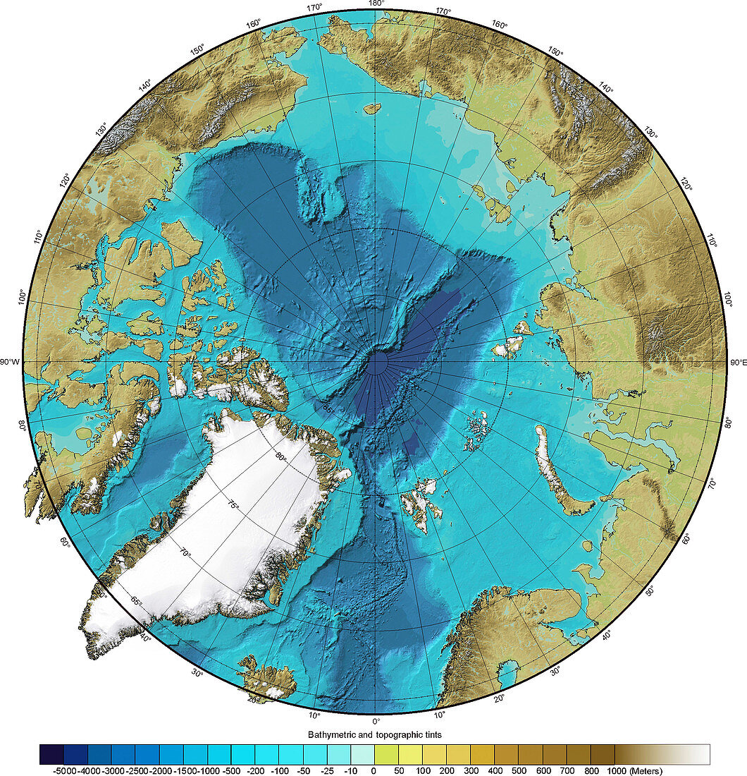
| Bathymetry and topography of the Arctic. This image is centred on the North Pole and shows the varying depths of the Arctic Ocean (with increasing depths going from turquoise to navy blue). The height of the land around the ocean varies,increasing from green through brown to white. This topographic map was constructed using a geographic information system (GIS) that captured,stored and analysed the Arctic region's topographic and bathymetric data. Topographic and bathymetric data is usually gathered by using aerial and satellite imagery combined with radar and sonar mapping. This project is the International Bathymetric Chart of the Arctic Ocean (IBCAO) and commenced in 1997 | |
| Licence : | Droits gérés |
| Crédit: | Science Photo Library / NOAA |
| Taille de l’image : | 2902 px × 3011 px |
| Model Release : | Non requis |
| Property Release : | Non requis |
| Restrictions : |
|
Prix pour cette image À partir de 45 €
Produit vendu
(Calendrier, Carte postale, Carte de vœux, Impression sur textile, Packaging etc)
À partir de 45 €
Usage commercial
(Affichage, Annonce presse, Annonce TV, Carte, Digital - hors rés. sociaux, Digital - rés. sociaux etc)
À partir de 45 €
Éditorial
(Digital, Journal, Livre, Livre pratique, Magazine, Télévision etc)
À partir de 60 €
Usage non-commercial
(Digital - hors rés. sociaux, Digital - rés. sociaux etc)
À partir de 120 €
Mots clés
- Arctique,
- bathymétrie,
- bathymétrique,
- calotte glaciaire,
- carte,
- cartographie,
- cartographier,
- cercle,
- cercle Artique,
- circulaire,
- continent,
- côte,
- côtier,
- de l'espace,
- diagramme,
- échosondeur,
- entier,
- fond de la mer,
- fond marin,
- fond sous-marin,
- fonds marins,
- géographie,
- géographique,
- géophysique,
- global,
- globe,
- graphique,
- hémisphère Nord,
- image satellite,
- mer,
- observation de la terre,
- océan,
- océan Artique,
- océanographie,
- océanographique,
- polaire,
- Pôle Nord,
- profond,
- profondément,
- profondeur océanique,
- région polaire,
- rond,
- satellite,
- schéma,
- sonar,
- tableau,
- terre,
- topographie,
- topographique