2006 El Nino development,07/08/2006
Numéro d’image : 11739673
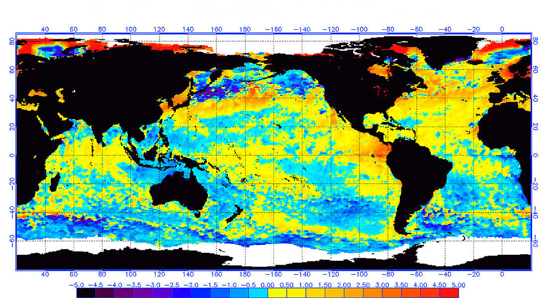
| 2006 El Nino development,image 1 of 2. Sea surface temperature map showing the development of El Nino conditions in the equatorial eastern Pacific Ocean. Sea surface temperatures are colour-coded according to the bar at bottom,with red being 5 degrees Celsius above average. The red patch in the ocean immediately west of northern South America is indicative of a developing El Nino. El Nino is a warming of surface waters in the tropical eastern Pacific Ocean. It may persist for a year or more,and causes drier conditions in Australia and South-East Asia,and wetter and warmer conditions in the Americas,with often dire effects for agriculture. For the same area on 11th September 2006,see image E265/036 | |
| Licence : | Droits gérés |
| Crédit: | Science Photo Library / NOAA |
| Taille de l’image : | 3500 px × 1909 px |
| Model Release : | Non requis |
| Property Release : | Non requis |
| Restrictions : |
|
Prix pour cette image À partir de 45 €
Produit vendu
(Calendrier, Carte postale, Carte de vœux, Impression sur textile, Packaging etc)
À partir de 45 €
Usage commercial
(Affichage, Annonce presse, Annonce TV, Carte, Digital - hors rés. sociaux, Digital - rés. sociaux etc)
À partir de 45 €
Éditorial
(Digital, Journal, Livre, Livre pratique, Magazine, Télévision etc)
À partir de 60 €
Usage non-commercial
(Digital - hors rés. sociaux, Digital - rés. sociaux etc)
À partir de 120 €
Mots clés
- 2006,
- 21ème siècle,
- anomalie,
- Août,
- avant,
- chauffage,
- chauffer,
- climatologie,
- climatologique,
- conditions,
- de l'espace,
- développement,
- développer,
- EL NINO,
- ENSO,
- état,
- image satellite,
- météo,
- météorologie,
- météorologique,
- NOAA,
- observation de la terre,
- océan,
- Océan Pacifique,
- précédent,
- satellite,
- température surface mer,
- terre,
- XX1ème siècle