Upheaval Crater,USA
Numéro d’image : 11746301
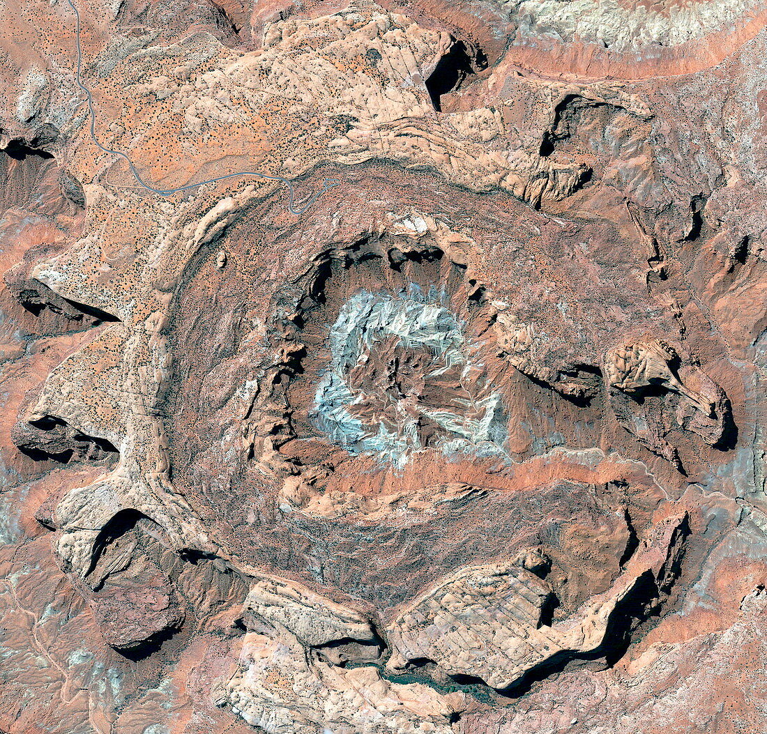
| Upheaval Crater,Utah,USA,satellite image. The area shown is about 5 kilometres across. There are several theories that attempt to explain how this crater was formed. The most widely accepted theory says that it was formed by a meteorite impact some 60 million years ago. The current appearance of concentric rings formed as erosion revealed the layers of sedimentary rock tilted upwards by the impact. The blue ring is a white sandstone called Permian White Rim Sandstone. The cliffs around the central area are over 400 metres tall. There is a road at upper left. Image taken by the Quickbird satellite,20 April 2003 | |
| Licence : | Droits gérés |
| Crédit: | Science Photo Library / Digital Globe, Eurimage |
| Taille de l’image : | 2600 px × 2489 px |
| Model Release : | Non requis |
| Property Release : | Non requis |
| Restrictions : |
|
Prix pour cette image À partir de 45 €
Produit vendu
(Calendrier, Carte postale, Carte de vœux, Impression sur textile, Packaging etc)
À partir de 45 €
Usage commercial
(Affichage, Annonce presse, Annonce TV, Carte, Digital - hors rés. sociaux, Digital - rés. sociaux etc)
À partir de 45 €
Éditorial
(Digital, Journal, Livre, Livre pratique, Magazine, Télévision etc)
À partir de 60 €
Usage non-commercial
(Digital - hors rés. sociaux, Digital - rés. sociaux etc)
À partir de 120 €
Mots clés
- 2003,
- américain,
- Amérique du Nord,
- anneau,
- anneaux,
- avril,
- cercle,
- circulaire,
- concentrique,
- couche,
- couches,
- cratère,
- cratère d'impact,
- de l'espace,
- déformé,
- désert,
- érodé,
- érosion,
- Etats-Unis,
- géographie,
- géographique,
- géologie,
- géologique,
- grandi,
- grès,
- image satellite,
- N/A,
- observation de la terre,
- Quickbird,
- réhaussé,
- roche,
- roches,
- rond,
- satellite,
- sédimentaire,
- soulevé,
- strates,
- US,
- USA,
- Utah