Desert oases,UAE
Numéro d’image : 11745824
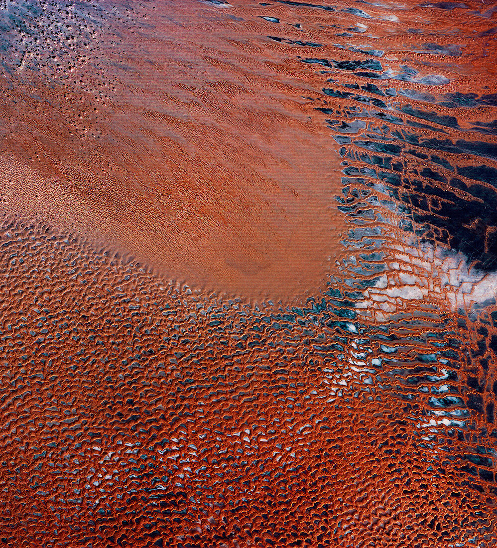
| Desert oases,United Arab Emirates (UAE),infrared satellite image. North is at top. This is one of the few habitable areas in the deserts (brown) of the UAE. Called Al-Liwa,the crescent-shaped area separates the sandy desert (upper left) from an area of gravel plains (dark blue,mostly upper right) surrounded by towering sand dunes (brown). Salty groundwater forms deposits (white),while a limited supply of fresh water supports agriculture in Al-Liwa. This 180-kilometre-wide image was taken on 11 November 1972,in visible and infrared wavelengths with the Multispectral Scanner (MSS) sensor on NASA's Landsat 1 satellite | |
| Licence : | Droits gérés |
| Crédit: | Science Photo Library / MDA Information Systems |
| Taille de l’image : | 3987 px × 4394 px |
| Model Release : | Non requis |
| Property Release : | Non requis |
| Restrictions : | - |
Prix pour cette image À partir de 45 €
Produit vendu
(Calendrier, Carte postale, Carte de vœux, Impression sur textile, Packaging etc)
À partir de 45 €
Usage commercial
(Affichage, Annonce presse, Annonce TV, Carte, Digital - hors rés. sociaux, Digital - rés. sociaux etc)
À partir de 45 €
Éditorial
(Digital, Journal, Livre, Livre pratique, Magazine, Télévision etc)
À partir de 60 €
Usage non-commercial
(Digital - hors rés. sociaux, Digital - rés. sociaux etc)
À partir de 120 €
Mots clés
- 1972,
- AL LIWA,
- AL-LIWA,
- arabe,
- aride,
- aridité,
- asiatique,
- Asie,
- canadarm2,
- de l'espace,
- désert,
- dune,
- dunes,
- E.A.U.,
- EAU,
- Emirats Arabes Unies,
- Emirats Arabes Unis,
- environnement,
- environnemental,
- géographie,
- géographique,
- infrarouge,
- Landsat 1,
- Moyen Orient,
- Moyen-Orient,
- multispectral,
- novembre,
- oasis,
- observation de la terre,
- sable,
- sableux,
- sablonneux,
- salé,
- satellite,
- saumure,
- sec,
- sel,
- système d'entretien mobile,
- un