Matang Mangrove Forest,satellite image
Numéro d’image : 11745628
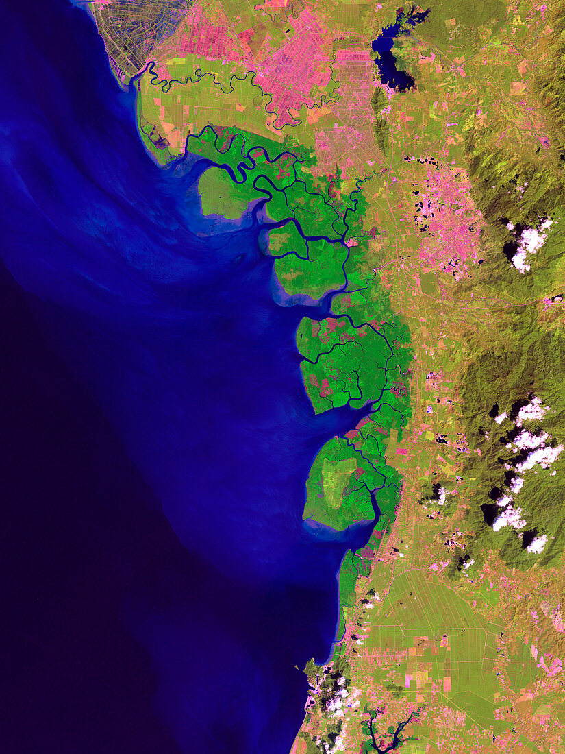
| Matang Mangrove Forest,Malaysia,satellite image. North is at top. The mangroves (centre) are dark green,while agricultural fields (rectangular) are light green. Urban or cleared areas,such as the city of Taiping (upper right),are pink. Mountains and clouds (white) are seen at far right. Deep water is dark blue,while sediment-laden waters emerging from the mangrove deltas are a lighter blue. Mangrove trees are adapted to growing in salty conditions. They support a diverse variety of plants and animals. Matang Mangrove Forest is a sustainably managed mangrove forest,and the largest in peninsular Malaysia. Image obtained in visible and infrared wavelengths on 27 December 1999 by the Landsat 7 satellite. This image is around 40 kilometres across | |
| Licence : | Droits gérés |
| Crédit: | Science Photo Library / NASA / US Geological Survey |
| Taille de l’image : | 2576 px × 3435 px |
| Model Release : | Non requis |
| Property Release : | Non requis |
| Restrictions : | - |
Prix pour cette image À partir de 45 €
Produit vendu
(Calendrier, Carte postale, Carte de vœux, Impression sur textile, Packaging etc)
À partir de 45 €
Usage commercial
(Affichage, Annonce presse, Annonce TV, Carte, Digital - hors rés. sociaux, Digital - rés. sociaux etc)
À partir de 45 €
Éditorial
(Digital, Journal, Livre, Livre pratique, Magazine, Télévision etc)
À partir de 60 €
Usage non-commercial
(Digital - hors rés. sociaux, Digital - rés. sociaux etc)
À partir de 120 €
Mots clés
- 1999,
- 20ème siècle,
- aquatique,
- asiatique,
- Asie,
- Asie du Sud Est,
- Asie du Sud-Est,
- biologie,
- biologique,
- côte,
- côtier,
- de l'espace,
- décembre,
- eau,
- écologie,
- écologique,
- écosystème,
- forêt de palétuviers,
- géographie,
- géographique,
- habitat,
- image satellite,
- infrarouge,
- IR,
- landsat 7,
- Malaisie,
- mangrove,
- mer,
- nature,
- observation de la terre,
- Océan Indien,
- optique,
- satellite,
- Taiping,
- ville,
- XXème siècle