Aral Sea reduction 1973-2000
Numéro d’image : 11745461
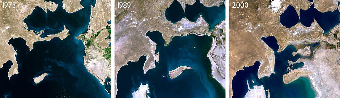
| Aral Sea reduction between 1973 and 2000,satellite images. North is at top. THe middle puicture dates from 1989. Since the 1960s the Aral Sea,on the borders of Uzbekistan (south west) and Kazakhstan (north east),has lost more than half of its volume. This is due to overuse of the feeder rivers (the Syr Darya and Amu Darya) in irrigation of cotton and paddy fields. The consequent receding waterline and increased salination has destroyed the region's fishing industry. Exposed areas of salt are blown by winds into the surrounding area,reducing crop yields | |
| Licence : | Droits gérés |
| Crédit: | Science Photo Library / Planetobserver |
| Taille de l’image : | 3543 px × 1028 px |
| Model Release : | Non requis |
| Property Release : | Non requis |
| Restrictions : | - |
Prix pour cette image À partir de 45 €
Produit vendu
(Calendrier, Carte postale, Carte de vœux, Impression sur textile, Packaging etc)
À partir de 45 €
Usage commercial
(Affichage, Annonce presse, Annonce TV, Carte, Digital - hors rés. sociaux, Digital - rés. sociaux etc)
À partir de 45 €
Éditorial
(Digital, Journal, Livre, Livre pratique, Magazine, Télévision etc)
À partir de 60 €
Usage non-commercial
(Digital - hors rés. sociaux, Digital - rés. sociaux etc)
À partir de 120 €
Mots clés
- 1973,
- 1989,
- 2000,
- à l'intérieur des terres,
- aride,
- aridité,
- Asie,
- assèchement,
- assécher,
- dans les terres,
- de l'espace,
- désert,
- eau saumâtre,
- environnement,
- évaporer,
- géographie,
- géographique,
- image satellite,
- Kazakhstan,
- lac,
- mer,
- Mer d'Aral,
- observation de la terre,
- Ouzbékistan,
- panoramique,
- recul,
- rétrécir,
- salé,
- satellite,
- sécher,
- sécheresse,
- sel,
- tarir,
- tarissement,
- trio,
- trois