3-D map of the ocean floor around Los Angeles,USA
Numéro d’image : 11740224
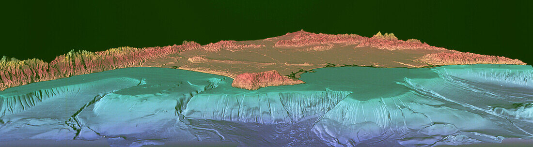
| Los Angeles sea floor. Coloured three-dimensional image of the ocean floor topography around Los Angeles,California,USA. North is towards top left. Areas below sea level are blue/green,those above it are pink. This map was made using multi- beam bathymetry,a form of ship-borne sonar,in which sound is reflected off the sea bed. The shallow continental shelf (green) extends from the land to the abrupt drop of the continental slope. These mapping techniques may be used for tracking toxic waste migration and for studying submarine earthquake faults. Los Angeles occupies the region behind the San Pedro Peninsula (centre). San Pedro Bay is at right,with Santa Monica Bay at left | |
| Licence : | Droits gérés |
| Crédit: | Science Photo Library / US Geological Survey |
| Taille de l’image : | 6413 px × 1772 px |
| Model Release : | Non requis |
| Property Release : | Non requis |
| Restrictions : | - |
Prix pour cette image À partir de 45 €
Produit vendu
(Calendrier, Carte postale, Carte de vœux, Impression sur textile, Packaging etc)
À partir de 45 €
Usage commercial
(Affichage, Annonce presse, Annonce TV, Carte, Digital - hors rés. sociaux, Digital - rés. sociaux etc)
À partir de 45 €
Éditorial
(Digital, Journal, Livre, Livre pratique, Magazine, Télévision etc)
À partir de 60 €
Usage non-commercial
(Digital - hors rés. sociaux, Digital - rés. sociaux etc)
À partir de 120 €