Tsunami,2004
Numéro d’image : 11739835
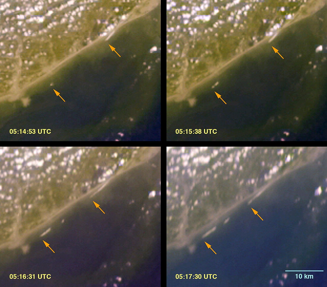
| Tsunami. Satellite image of the progress of the 26 December 2004 tsunami wave,off the coast of Sumatra,Indonesia. The images are chronological,left to right top to bottom,and the tsunami wave is marked by red arrows. The time period from first to last is 2 minutes 30 seconds. It shows that the wave was travelling at around 30 kilometres per hour,although in deep water it would have been far smaller but travelling at a velocity of over 600 kilometres per hour. This tsunami was caused by an undersea earthquake of magnitude 9 on the Richter scale. It was the largest quake in 40 years and over 150,000 people were killed | |
| Licence : | Droits gérés |
| Crédit: | Science Photo Library / NASA |
| Taille de l’image : | 2700 px × 2364 px |
| Model Release : | Non requis |
| Property Release : | Non requis |
| Restrictions : | - |
Prix pour cette image À partir de 45 €
Produit vendu
(Calendrier, Carte postale, Carte de vœux, Impression sur textile, Packaging etc)
À partir de 45 €
Usage commercial
(Affichage, Annonce presse, Annonce TV, Carte, Digital - hors rés. sociaux, Digital - rés. sociaux etc)
À partir de 45 €
Éditorial
(Digital, Journal, Livre, Livre pratique, Magazine, Télévision etc)
À partir de 60 €
Usage non-commercial
(Digital - hors rés. sociaux, Digital - rés. sociaux etc)
À partir de 120 €
Mots clés
- Asie du Sud-Est,
- catastrophe naturelle,
- catastrophique,
- côte,
- de l'espace,
- dévastateur,
- géographie,
- géographique,
- image satellite,
- Indonésie,
- littoral,
- mathématique,
- mathématiques,
- mécanique des fluides,
- observation de la terre,
- Océan Pacifique,
- raz de marée,
- raz-de-marée,
- satellite,
- sismologie,
- Sumatra,
- terra,
- terre,
- tsunami,
- vague