Saudi Arabian Agricultural Field Increase
Numéro d’image : 12630512
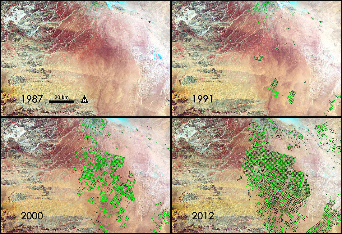
| Saudi Arabia is drilling for a resource possibly more precious than oil. Over the last 24 years, it has tapped hidden reserves of water to grow wheat and other crops in the Syrian Desert. This time series of data shows images acquired by three different Landsat satellites operated by NASA and the U.S. Geological Survey. In this series of four Landsat images, the agricultural fields are about one kilometre (.62 miles) across. The images were created using reflected light from the short wave-infrared, near-infrared, and green portions of the electromagnetic spectrum (bands 7, 4, and 2 from Landsat 4 and 5 TM and Landsat 7 ETM+ sensors). Using this combination of wavelengths, healthy vegetation appears bright green while dry vegetation appears orange. Barren soil is a dark pink, and urban areas, like the town of Tubarjal at the top of each image, have a purple hue. | |
| Licence : | Droits gérés |
| Crédit: | Science Photo Library / NASA's Goddard Space Flight Center |
| Taille de l’image : | 4500 px × 3084 px |
| Model Release : | Non requis |
| Property Release : | Non requis |
| Restrictions : | - |
Prix pour cette image À partir de 45 €
Produit vendu
(Calendrier, Carte postale, Carte de vœux, Impression sur textile, Packaging etc)
À partir de 45 €
Usage commercial
(Affichage, Annonce presse, Annonce TV, Carte, Digital - hors rés. sociaux, Digital - rés. sociaux etc)
À partir de 45 €
Éditorial
(Digital, Journal, Livre, Livre pratique, Magazine, Télévision etc)
À partir de 60 €
Usage non-commercial
(Digital - hors rés. sociaux, Digital - rés. sociaux etc)
À partir de 120 €
Mots clés
- 1980,
- 1987,
- 1990,
- 1991,
- 2000,
- 2010,
- 2012,
- 20ème siècle,
- 21ème siècle,
- agricole,
- agriculture,
- Arabia,
- Arabie,
- Arabie Saoudite,
- ASAI,
- Asie de l'ouest,
- asie du Sud-Ouest,
- Asie occidentale,
- augmenter,
- champs,
- champs de blé,
- comparaison,
- croissance,
- géographie,
- image satellite,
- Landsat,
- Landsat 5,
- landsat 7,
- Moyen-Orient,
- péninsule arabe,
- péninsule arabique,
- saoudien,
- terre vue de l'espace,
- topographie,
- végétation,
- XX1ème siècle,
- XXème siècle