New Orleans After Hurricane Katrina
Numéro d’image : 12035224
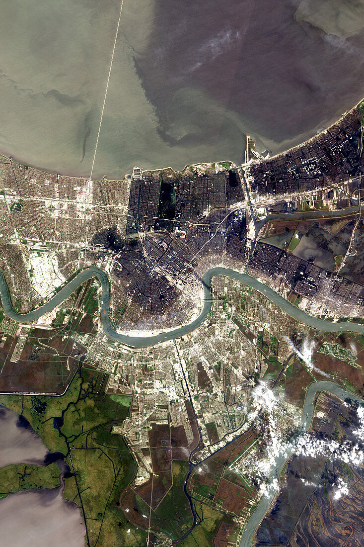
| New Orleans after Hurricane Katrina made landfall on August 29th,2005. This image,showing the flooded city (dark areas) was acquired on September 6,2005. Hurricane Katrina left a trail of destruction on the Gulf of Mexico coast of the USA,notably in New Orleans. There,the high winds,rain and storm surge caused the low-lying city's flood defences to fail. Around 80% of New Orleans was flooded,with thousands killed. The evacuation of all the city's 1.3 million residents was ordered on September 8th. The Advanced Land Imager on NASA's EO-1 satellite acquired this detailed image of the flooded city | |
| Licence : | Droits gérés |
| Crédit: | Science Photo Library / Lawrence Ong, EO-1 Mission Science Office, NASA GSFC |
| Taille de l’image : | 2800 px × 4200 px |
| Model Release : | Non requis |
| Property Release : | Non requis |
| Restrictions : |
|
Prix pour cette image À partir de 45 €
Produit vendu
(Calendrier, Carte postale, Carte de vœux, Impression sur textile, Packaging etc)
À partir de 45 €
Usage commercial
(Affichage, Annonce presse, Annonce TV, Carte, Digital - hors rés. sociaux, Digital - rés. sociaux etc)
À partir de 45 €
Éditorial
(Digital, Journal, Livre, Livre pratique, Magazine, Télévision etc)
À partir de 60 €
Usage non-commercial
(Digital - hors rés. sociaux, Digital - rés. sociaux etc)
À partir de 120 €
Mots clés
- 2005,
- aérien,
- américain,
- Amérique,
- catastrophe naturelle,
- crue,
- dégâts,
- destruction,
- dévastation,
- dommage,
- eaux fluviales,
- Etats-Unis,
- image satellite,
- inondation,
- Katrina,
- Louisiane,
- météo,
- N/A,
- Nouvelle Orléans,
- ouragan,
- ouragan Katrina,
- tempête grave,
- tempête importante,
- US,
- USA,
- ville,
- vue par satellite,
- vue satellite