Martian topography
Numéro d’image : 11882271
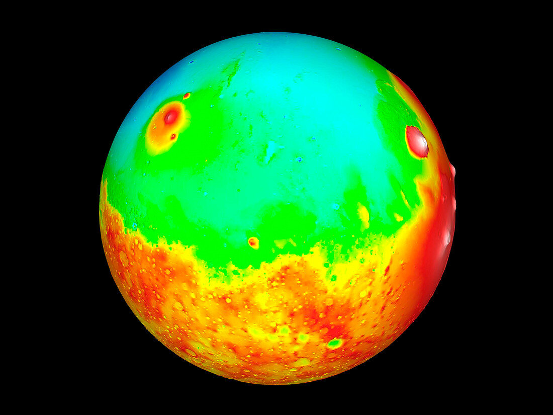
| Martian topography. Three-dimensional map of the topography of Mars. Elevation is colour-coded,from white (highest) through red,yellow and green to blue (lowest). The Martian equator runs along centre. Three volcanoes (white) are seen on the limb at right. From bottom to top,these are Arsia Mons,Pavonis Mons and Ascraeus Mons. To their left is Olympus Mons (white),the largest volcano in the solar system. At upper left is Elysium Mons (red),another volcano. Data collected by the Mars Orbiter Laser Altimeter (MOLA) on the Mars Global Surveyor spacecraft. 27 million height measurements were made by timing laser pulses sent to Mars' surface | |
| Licence : | Droits gérés |
| Crédit: | Science Photo Library / NASA |
| Taille de l’image : | 2560 px × 1920 px |
| Model Release : | Non requis |
| Property Release : | Non requis |
| Restrictions : | - |
Prix pour cette image À partir de 45 €
Produit vendu
(Calendrier, Carte postale, Carte de vœux, Impression sur textile, Packaging etc)
À partir de 45 €
Usage commercial
(Affichage, Annonce presse, Annonce TV, Carte, Digital - hors rés. sociaux, Digital - rés. sociaux etc)
À partir de 45 €
Éditorial
(Digital, Journal, Livre, Livre pratique, Magazine, Télévision etc)
À partir de 60 €
Usage non-commercial
(Digital - hors rés. sociaux, Digital - rés. sociaux etc)
À partir de 120 €
Mots clés
- 3 dimensions,
- 3D,
- altimètre de laser de navette spatiale,
- ASCRAEUS,
- astronomie,
- astrophysiques,
- carte topographique,
- cosmologie,
- ELYSIUM MONS,
- Mars,
- mars global surveyor,
- martien,
- MGS,
- MOLA,
- Olympe,
- PAVONIS,
- planétaire,
- planète,
- science,
- science planétaire,
- topographie,
- tridimensionnel,
- tridimensionnelle,
- volcans