Earth graphics of 1997 El Nino sea temperatures
Numéro d’image : 11739663
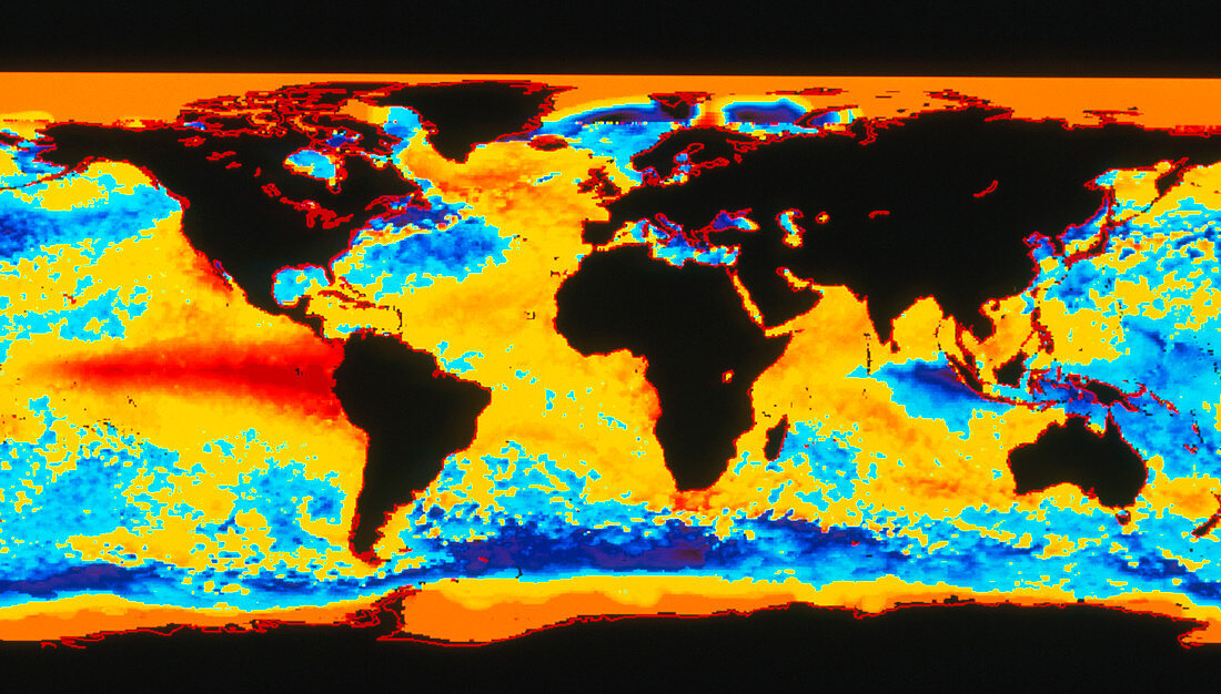
| 1997 El Nino. Coloured satellite image of Earth showing the 1997 El Nino event in the east Pacific Ocean. The El Nino affects global weather,causing unseasonal droughts & storms. The difference bet- ween normal sea temperatures & those during the El Nino are shown as colours from purple (furthest below normal) through blue & yellow to red (furth- est above normal). Land masses are black and out- lined in red. The El Nino is the red area moving eastwards along the equator across the Pacific. Image taken by an Advanced Very High Resolution Radiometer on a NOAA satellite on 3 November 1997 | |
| Licence : | Droits gérés |
| Crédit: | Science Photo Library / NOAA |
| Taille de l’image : | 4357 px × 2480 px |
| Model Release : | Non requis |
| Property Release : | Non requis |
| Restrictions : |
|
Prix pour cette image À partir de 45 €
Produit vendu
(Calendrier, Carte postale, Carte de vœux, Impression sur textile, Packaging etc)
À partir de 45 €
Usage commercial
(Affichage, Annonce presse, Annonce TV, Carte, Digital - hors rés. sociaux, Digital - rés. sociaux etc)
À partir de 45 €
Éditorial
(Digital, Journal, Livre, Livre pratique, Magazine, Télévision etc)
À partir de 60 €
Usage non-commercial
(Digital - hors rés. sociaux, Digital - rés. sociaux etc)
À partir de 120 €