Ozone hole over Antarctica
Numéro d’image : 11736308
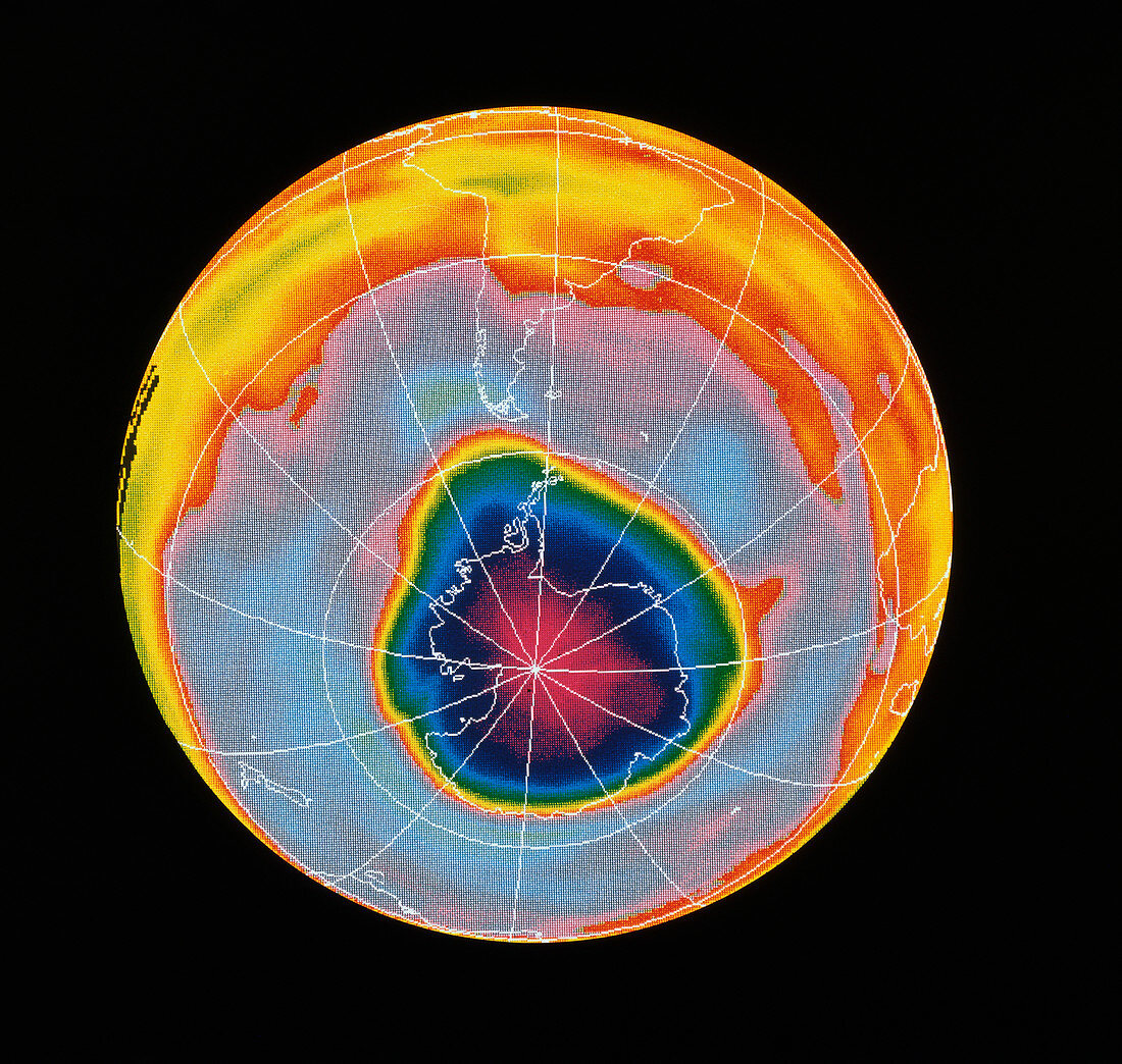
| Satellite map showing a severe depletion or "hole" in the ozone layer over Antarctica on October 3rd,1990. The hole is believed to be due to pollution of the atmosphere by chlorofluorocarbons used in aerosols & refrigerants. First observed in 1980,the most severe depletion was recorded in October 1987. This image represents the maximum depletion during the Antarctic spring of 1990. It appears here as the violet and pink areas covering Antarctica (outlined in white) and beyond. The scale of colours represents Dobson units,a measure of atmospheric ozone. The map was made by the Total Ozone Mapping Spectrometer (TOMS) on the American Nimbus-7 weather satellite | |
| Licence : | Droits gérés |
| Crédit: | Science Photo Library / NASA |
| Taille de l’image : | 4313 px × 4095 px |
| Model Release : | Non requis |
| Property Release : | Non requis |
| Restrictions : | - |
Prix pour cette image À partir de 45 €
Produit vendu
(Calendrier, Carte postale, Carte de vœux, Impression sur textile, Packaging etc)
À partir de 45 €
Usage commercial
(Affichage, Annonce presse, Annonce TV, Carte, Digital - hors rés. sociaux, Digital - rés. sociaux etc)
À partir de 45 €
Éditorial
(Digital, Journal, Livre, Livre pratique, Magazine, Télévision etc)
À partir de 60 €
Usage non-commercial
(Digital - hors rés. sociaux, Digital - rés. sociaux etc)
À partir de 120 €
Mots clés
- Antarctique,
- atmosphère,
- CFC,
- climat,
- couche ozone,
- dans la couche d'ozone,
- dégradation de la couche d'ozone,
- destruction de la couche d'ozone,
- géographie,
- image satellite,
- imagerie de Nimbus 7,
- imagerie Nimbus 7,
- imagerie satellitaire,
- imagerie satellite,
- orifice,
- ozone,
- pollution,
- pollution atmosphérique,
- science de la terre,
- sciences,
- terre,
- terrien,
- trou,
- trou de la couche d'ozone