Maps of China and the world
Numéro d’image : 11735511
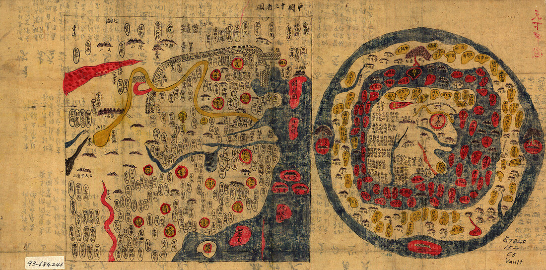
| Image 1 of 2. Maps of China and the world. Historical maps depicting the Ming Empire of China (left) and the world (right),with China at the centre. The Yellow (upper) and Yangtze (blue,lower) rivers are clearly seen. The world map depicts China as an island surrounded by water and an all encircling world. The Great Wall of China,started in 7BC,is seen on both maps. The wall was renovated during the Ming dynasty,which began in 1368. This map is believed to date from around 1800,but may have been based on an earlier map of unknown date. Text written on the reverse of the sheet can be seen faintly. For an image of the reverse of the sheet,see E056/049 | |
| Licence : | Droits gérés |
| Crédit: | Science Photo Library / Library of Congress |
| Taille de l’image : | 5916 px × 2924 px |
| Model Release : | Non requis |
| Property Release : | Non requis |
| Restrictions : | - |
Prix pour cette image À partir de 45 €
Produit vendu
(Calendrier, Carte postale, Carte de vœux, Impression sur textile, Packaging etc)
À partir de 45 €
Usage commercial
(Affichage, Annonce presse, Annonce TV, Carte, Digital - hors rés. sociaux, Digital - rés. sociaux etc)
À partir de 45 €
Éditorial
(Digital, Journal, Livre, Livre pratique, Magazine, Télévision etc)
À partir de 60 €
Usage non-commercial
(Digital - hors rés. sociaux, Digital - rés. sociaux etc)
À partir de 120 €
Mots clés
- 1800,
- 19,
- 19ème,
- 19ème siècle,
- ancien,
- asiatique,
- Asie,
- carte,
- cartes,
- cartographie,
- cartographier,
- Chine,
- chinois,
- découvrir,
- défilement,
- empire,
- exploration,
- explorer,
- faire défiler,
- géographie,
- géographique,
- histoire,
- historique,
- illustration,
- jaune,
- monde,
- monde connu,
- oeuvre,
- oriental,
- parchemin,
- rivière,
- rivières,
- rouleau,
- science de la terre,
- sciences,
- vieux,
- XIXème siècle,
- Yangtze