Global temperature
Numéro d’image : 11734942
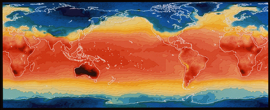
| Global temperature. Satellite map of the world's average surface temperature in January 1979. Colours represent temperature as follows: mauve = -38 degrees C; blue = -36 to -12 degrees C; green = -10 to zero degrees C; yellow = 2 to 14 degrees C; pink & red = 16 to 34 degrees C; deep red & black (as in Australia) = 36 to 40 degrees C. The data for the map was recorded by the High Resolution Infrared Sounder (HIRS) and Microwave Sounding Unit (MSU) instruments on board one of the satellites of the US National Oceanic and Atmospheric Organization (NOAA) | |
| Licence : | Droits gérés |
| Crédit: | Science Photo Library / NASA |
| Taille de l’image : | 5972 px × 2441 px |
| Model Release : | Non requis |
| Property Release : | Non requis |
| Restrictions : | - |
Prix pour cette image À partir de 45 €
Produit vendu
(Calendrier, Carte postale, Carte de vœux, Impression sur textile, Packaging etc)
À partir de 45 €
Usage commercial
(Affichage, Annonce presse, Annonce TV, Carte, Digital - hors rés. sociaux, Digital - rés. sociaux etc)
À partir de 45 €
Éditorial
(Digital, Journal, Livre, Livre pratique, Magazine, Télévision etc)
À partir de 60 €
Usage non-commercial
(Digital - hors rés. sociaux, Digital - rés. sociaux etc)
À partir de 120 €
Mots clés
- carte,
- carte du monde,
- carte satellite,
- cartographie,
- chaleur,
- changement climatique,
- géographie,
- image satellite,
- imagerie satellitaire,
- imagerie satellite,
- images,
- océanographie,
- océanographique,
- photo,
- photos,
- réchauffement climatique,
- science de la terre,
- sciences,
- température,
- température surface mer,
- terre