Dutch map of Nagasaki,18th century
Numéro d’image : 11730639
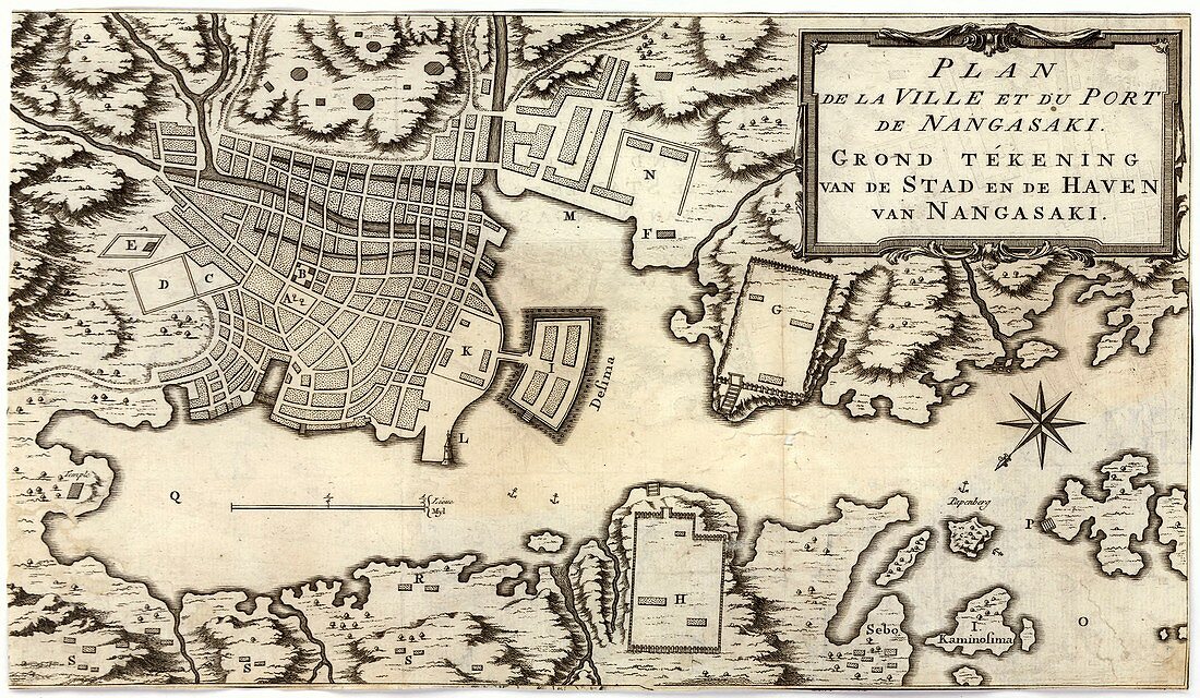
| Dutch map of Nagasaki. 18th-century map of Nagasaki,Japan,with a bilingual (French and Dutch) title. The French title is: Plan de la ville et du port de Nangasaki. The Dutch title is: Grond tekening van de stad en de haven van Nangaski. Both translate as 'Map of the city and the port of Nagasaki'. The map shows the Emperor's Palace,the Governor's houses,temples,the house of the Port inspector and the Chinese quarter. Nagasaki was the main entry point for Westerners into Japan at this time. The area at centre is the Dejima,a Portuguese island-prison. From 1720,a ban on Dutch books was lifted and scholars came here to study European science and art | |
| Licence : | Droits gérés |
| Crédit: | Science Photo Library / LIBRARY OF CONGRESS, Geography and Map Division |
| Taille de l’image : | 4245 px × 2469 px |
| Model Release : | Non requis |
| Property Release : | Non requis |
| Restrictions : | - |
Prix pour cette image À partir de 45 €
Produit vendu
(Calendrier, Carte postale, Carte de vœux, Impression sur textile, Packaging etc)
À partir de 45 €
Usage commercial
(Affichage, Annonce presse, Annonce TV, Carte, Digital - hors rés. sociaux, Digital - rés. sociaux etc)
À partir de 45 €
Éditorial
(Digital, Journal, Livre, Livre pratique, Magazine, Télévision etc)
À partir de 60 €
Usage non-commercial
(Digital - hors rés. sociaux, Digital - rés. sociaux etc)
À partir de 120 €
Mots clés
- 1700,
- 18ème siècle,
- atlas,
- aucun,
- carte,
- cartographie,
- DEJIMA,
- géographie,
- géographique,
- histoire,
- historique,
- île,
- illustration,
- inscription,
- monochrome,
- n/b,
- Nagasaki,
- néerlandais,
- noir et blanc,
- noir-et-blanc,
- oeuvre,
- personne,
- plan,
- port,
- portugais,
- prison,
- publication,
- schéma,
- temples,
- titre,
- urbain,
- ville,
- XVIIIème siècle