Chinese world map,17th century
Numéro d’image : 11613984
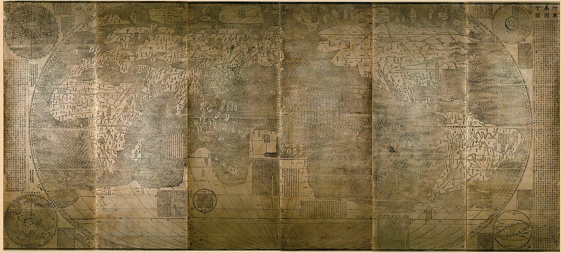
| Chinese world map. Comprised of six vertical wood block print sections,this world map was produced by the Italian Jesuit priest Matteo Ricci (1552-1610) and published in China in 1602 (original edition 1584). It is a pseudocylindrical projection centred on the Pacific Ocean. The main continents (Europe,Africa,Asia,the Americas) are accurate,but the as-yet-undiscovered southern land masses are called 'Magellanica' (Terra Australis). In the corners are polar maps of the northern and southern hemispheres (left),the geocentric world system (upper right),and celestial and zodiacal circles (lower right). The text is Chinese | |
| Licence : | Droits gérés |
| Crédit: | Science Photo Library / Library of Congress |
| Taille de l’image : | 8820 px × 3969 px |
| Model Release : | Non requis |
| Property Release : | Non requis |
| Restrictions : | - |
Prix pour cette image À partir de 45 €
Produit vendu
(Calendrier, Carte postale, Carte de vœux, Impression sur textile, Packaging etc)
À partir de 45 €
Usage commercial
(Affichage, Annonce presse, Annonce TV, Carte, Digital - hors rés. sociaux, Digital - rés. sociaux etc)
À partir de 45 €
Éditorial
(Digital, Journal, Livre, Livre pratique, Magazine, Télévision etc)
À partir de 60 €
Usage non-commercial
(Digital - hors rés. sociaux, Digital - rés. sociaux etc)
À partir de 120 €
Mots clés
- 1600,
- 17ème siècle,
- africain,
- Afrique,
- Amérique du Nord,
- Amérique du Sud,
- asiatique,
- Asie,
- carte,
- carte du monde,
- cartographie,
- cartographique,
- Chine,
- chinois,
- cylindrique,
- Europe,
- européen,
- géographie,
- géographique,
- histoire,
- historique,
- illustration,
- Italien,
- JAMES FORD BELL LIBRARY,
- Jesuit,
- jésuite,
- manuscript chinois,
- oeuvre,
- Sud Américain,
- Sud-Américain,
- TERRA AUSTRALIS,
- terre,
- XVIIème siècle,
- zodiacal,
- zodiaque