La Nina Winter
Numéro d’image : 12632622
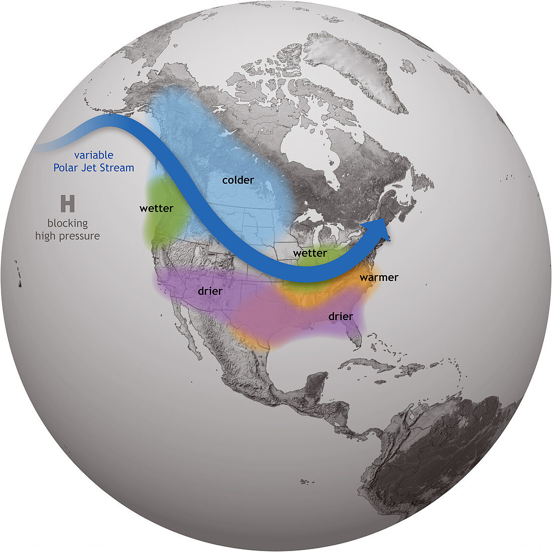
| El Nino and La Nina are opposite phases of a natural climate pattern across the tropical Pacific Ocean that swings back and forth every 3-7 years on average. El Nino and La Nina alternately warm and cool large areas of the tropical Pacific, which significantly influences where and how much it rains there. They disrupt the atmospheric circulation patterns that connect the tropics with the middle latitudes, which in turn modify the mid-latitude jet streams. ENSO can affect temperature and precipitation across the U.S. and other parts of the world. The influence on the U.S. is strongest during winter, but it lingers into the early spring. This map illustrates the typical impacts on U.S. winter weather. During El Nino, the southern tier of Alaska and the U.S. Pacific Northwest tend to be warmer than average, whereas the U.S. southern states, from California to the Carolinas, tends to be cooler and wetter. During La Nina, these deviations from the average | |
| Licence : | Droits gérés |
| Crédit: | Science Photo Library / Science Source / NOAA |
| Taille de l’image : | 3750 px × 3750 px |
| Model Release : | Non requis |
| Property Release : | Non requis |
| Restrictions : | - |
Prix pour cette image À partir de 45 €
Produit vendu
(Calendrier, Carte postale, Carte de vœux, Impression sur textile, Packaging etc)
À partir de 45 €
Usage commercial
(Affichage, Annonce presse, Annonce TV, Carte, Digital - hors rés. sociaux, Digital - rés. sociaux etc)
À partir de 45 €
Éditorial
(Digital, Journal, Livre, Livre pratique, Magazine, Télévision etc)
À partir de 60 €
Usage non-commercial
(Digital - hors rés. sociaux, Digital - rés. sociaux etc)
À partir de 120 €
Mots clés
- 20ème siècle,
- 21ème siècle,
- américain,
- Amérique,
- Amérique du Nord,
- carte,
- climat,
- climatologie,
- comparaison,
- comparer,
- cyclique,
- Etats-Unis,
- événement,
- globe,
- graphique,
- hiver,
- La Nina,
- météorologie,
- météorologique,
- modèle météo,
- modèle météorologique,
- N/A,
- Océan Pacifique,
- océanographie,
- océanographique,
- phénomène atmosphérique,
- phénomènes atmosphériques,
- recherche,
- schéma,
- US,
- USA,
- XX1ème siècle,
- XXème siècle