Crater Lake
Numéro d’image : 11740624
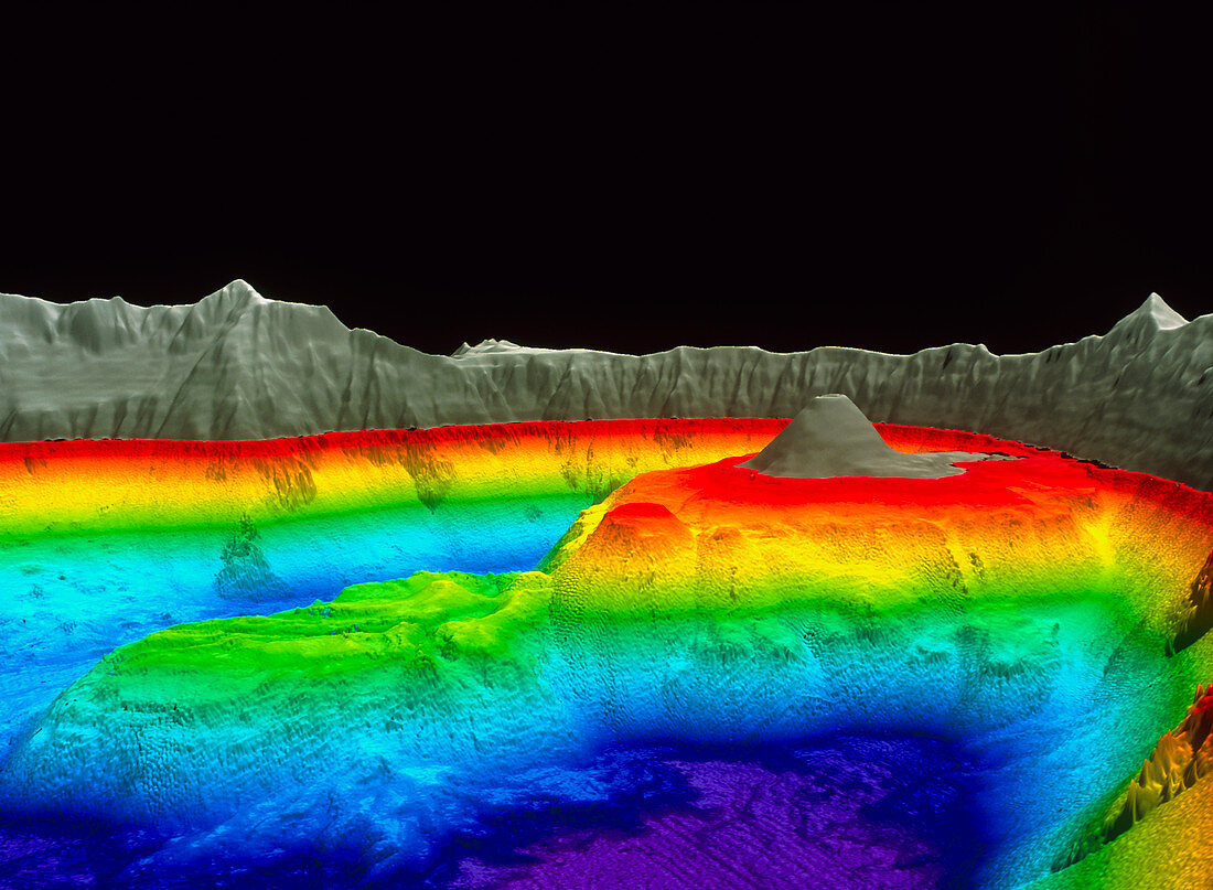
| Crater Lake. Coloured three-dimensional shaded- relief water depth map of Crater Lake,Oregon,which lies in a volcanic crater,or caldera. The map was created from over 50 million sonar depth readings. At 608 metres,this is the deepest US lake. The view is towards the south-east. Land is grey,with water depth colour-coded from purple (deepest),through blue,green and yellow to red (shallowest). Wizard Island (grey,centre right) and Rhyodacite Dome (red,centre) are volcanic cones. The caldera formed when the volcano Mount Mazama blew itself apart 7700 years ago. The data were collected from July 2000. The image's vertical exaggeration is x2 | |
| Licence : | Droits gérés |
| Crédit: | Science Photo Library / US Geological Survey |
| Taille de l’image : | 5165 px × 3787 px |
| Model Release : | Non requis |
| Property Release : | Non requis |
| Restrictions : | - |
Prix pour cette image À partir de 45 €
Produit vendu
(Calendrier, Carte postale, Carte de vœux, Impression sur textile, Packaging etc)
À partir de 45 €
Usage commercial
(Affichage, Annonce presse, Annonce TV, Carte, Digital - hors rés. sociaux, Digital - rés. sociaux etc)
À partir de 45 €
Éditorial
(Digital, Journal, Livre, Livre pratique, Magazine, Télévision etc)
À partir de 60 €
Usage non-commercial
(Digital - hors rés. sociaux, Digital - rés. sociaux etc)
À partir de 120 €
Mots clés
- 3 D,
- 3 dimensions,
- 3-D,
- 3D,
- américain,
- bassin,
- bathymétrie,
- caldera,
- cratère volcanique,
- cuvette,
- Etats-Unis,
- étude géologique,
- géographie,
- géologie,
- île Wizard,
- institut d'études géologiques des états-unis,
- lac de cratère,
- lavabo,
- Orégon,
- sonar,
- tridimensionnel,
- tridimensionnelle,
- trois dimensions,
- USA,
- USGS,
- volcan,
- volcanique,
- vulcanologie