Greenland Ice Sheet stratigraphy
Numéro d’image : 11718661
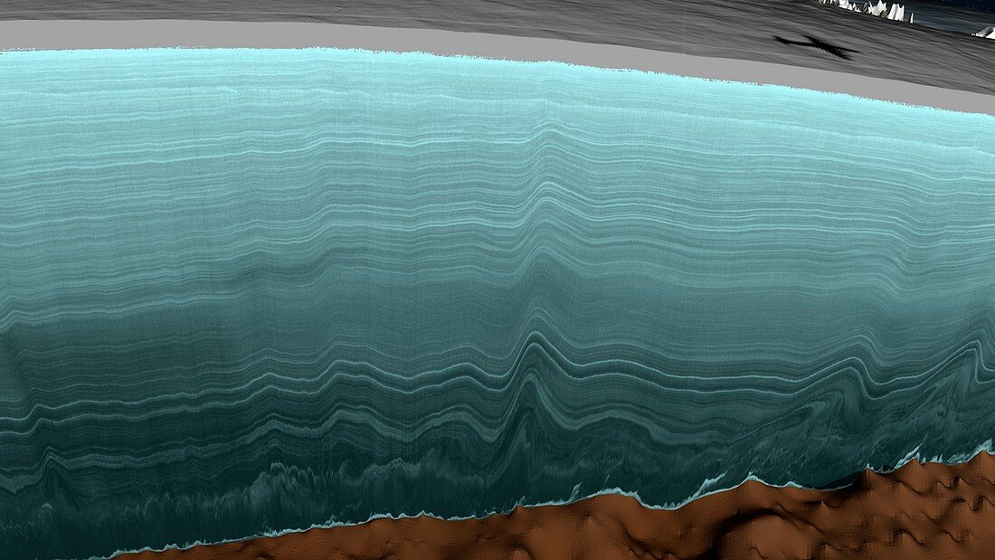
| Greenland Ice Sheet stratigraphy. Computer graphic showing the stratigraphy data collected by a radar aircraft flight over the Greenland Ice Sheet. This is a mass of ice with an area of 1.7 million square kilometres,reaching a thickness of over 3 kilometres. The resulting visualisation is known as a radargram. The shadow of the aircraft is at top right. This data was collected by one of the flights that form part of NASA's Operation IceBridge (2009-2016). This flight took place on 2 May 2011. The oldest ice,across bottom near the bedrock,is over 90,000 years old. For the lines colour-coded and with age labels,see image C025/8969 | |
| Licence : | Droits gérés |
| Crédit: | Science Photo Library / Scientific Visualization Studio / NASA |
| Taille de l’image : | 5573 px × 3135 px |
| Model Release : | Non requis |
| Property Release : | Non requis |
| Restrictions : | - |
Prix pour cette image À partir de 45 €
Produit vendu
(Calendrier, Carte postale, Carte de vœux, Impression sur textile, Packaging etc)
À partir de 45 €
Usage commercial
(Affichage, Annonce presse, Annonce TV, Carte, Digital - hors rés. sociaux, Digital - rés. sociaux etc)
À partir de 45 €
Éditorial
(Digital, Journal, Livre, Livre pratique, Magazine, Télévision etc)
À partir de 60 €
Usage non-commercial
(Digital - hors rés. sociaux, Digital - rés. sociaux etc)
À partir de 120 €
Mots clés
- aéroplane,
- âge,
- âge de glace,
- Arctique,
- aucun,
- avion,
- calotte glaciaire,
- catégorie,
- couche,
- couches,
- coupe,
- coupe transversale,
- divisé,
- géographie,
- géographie physique,
- géographique,
- géologie,
- géologique,
- géophysique,
- glace,
- glaciologie,
- Groenland,
- histoire,
- historique,
- holocène,
- NASA,
- ombre,
- partie,
- personne,
- préhistoire,
- préhistorique,
- radar,
- recherche,
- Sciences de la Terre,
- section