Saudi Arabia,satellite image
Numéro d’image : 11629499
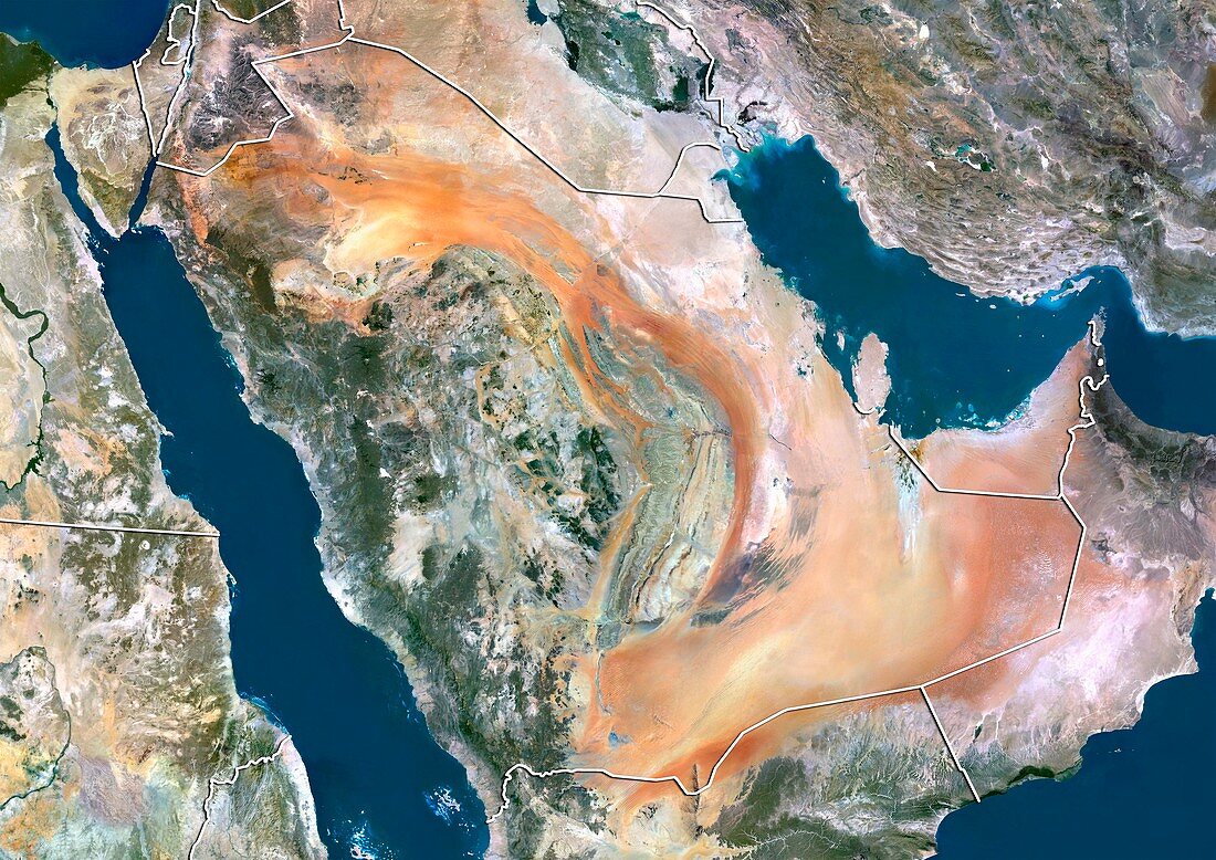
| Saudi Arabia,satellite image. North is at top. Natural colour satellite image showing Saudi Arabia (centre) and the surrounding territories. The Kingdom of Saudi Arabia is the largest state in Western Asia and constitutes the bulk of the Arabian Peninsula. It is bordered by Jordan (upper left),Iraq (top centre),Kuwait (small,upper right),Qatar (small peninsula,centre right),the United Arab Emirates (UAE,centre right),Oman (lower right),and Yemen (bottom centre). The Red Sea (blue,left) lies to its west,and the Persian Gulf (blue,upper right) lies to the east. The Gulf of Aden (blue,far right),Arabian Sea,(blue,lower right),and Mediterranean Sea (blue,upper left) can also be seen. Image compiled from data acquired by the LANDSAT 5 and 7 | |
| Licence : | Droits gérés |
| Crédit: | Science Photo Library / Planetobserver |
| Taille de l’image : | 4919 px × 3481 px |
| Model Release : | Non requis |
| Restrictions : | - |
Prix pour cette image À partir de 45 €
Produit vendu
(Calendrier, Carte postale, Carte de vœux, Impression sur textile, Packaging etc)
À partir de 45 €
Usage commercial
(Affichage, Annonce presse, Annonce TV, Carte, Digital - hors rés. sociaux, Digital - rés. sociaux etc)
À partir de 45 €
Éditorial
(Digital, Journal, Livre, Livre pratique, Magazine, Télévision etc)
À partir de 60 €
Usage non-commercial
(Digital - hors rés. sociaux, Digital - rés. sociaux etc)
À partir de 120 €
Mots clés
- 2000,
- 21ème siècle,
- asiatique,
- Asie,
- Asie de l'ouest,
- asie du Sud-Ouest,
- Asie occidentale,
- carte,
- cartographie,
- côte,
- côtier,
- couleur naturelle,
- d'en haut,
- de l'espace,
- du haut,
- E.A.U.,
- eau,
- Emirats Arabes Unies,
- Emirats Arabes Unis,
- environnement,
- environnemental,
- état,
- frontalier,
- frontière,
- frontières,
- géographie,
- géographique,
- Golfe Persique,
- image satellite,
- Irak,
- Jordanie,
- Koweït,
- Landsat 5,
- landsat 7,
- limite,
- limites,
- littoral,
- mer arabique,
- mer d'Arabie,
- mer d'Oman,
- Mer Méditérrannée,
- Mer Rouge,
- Moyen Orient,
- Moyen-Orient,
- nation,
- nature,
- observation de la terre,
- Oman,
- pays,
- péninsule arabe,
- péninsule arabique,
- plongeant,
- Qatar,
- rivage,
- rive,
- Royaume Uni,
- Royaume-Uni,
- satellite,
- terre,
- topographie,
- topographique,
- vue aérienne,
- vue d'oeil d'oiseau,
- XX1ème siècle,
- Yémen