Spanish North America,1600
Numéro d’image : 11622214
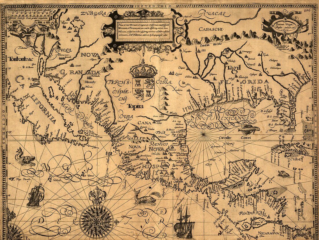
| Spanish North America. 1600 map of the southern regions of North America,including California,Mexico and Florida. The labels and text are in Latin. At the time,this area was claimed by the Spanish (Castilian crown and coat-of-arms below title cartouche),as shown by names such as Nova Hispania and Nova Galicia (both now in Mexico),and Nova Granada (New Mexico). Details include rivers,cities,mountains,coastlines,sea monsters,sailing ships,a compass rose,and rhumb lines. This map was produced by the London cartographer Gabriel Tatton (named at top centre) and the English engraver Benjamin Wright (named at upper right) | |
| Licence : | Droits gérés |
| Crédit: | Science Photo Library / Library of Congress |
| Taille de l’image : | 4835 px × 3640 px |
| Model Release : | Non requis |
| Property Release : | Non requis |
| Restrictions : | - |
Prix pour cette image À partir de 45 €
Produit vendu
(Calendrier, Carte postale, Carte de vœux, Impression sur textile, Packaging etc)
À partir de 45 €
Usage commercial
(Affichage, Annonce presse, Annonce TV, Carte, Digital - hors rés. sociaux, Digital - rés. sociaux etc)
À partir de 45 €
Éditorial
(Digital, Journal, Livre, Livre pratique, Magazine, Télévision etc)
À partir de 60 €
Usage non-commercial
(Digital - hors rés. sociaux, Digital - rés. sociaux etc)
À partir de 120 €
Mots clés
- 1600,
- 17ème siècle,
- âge de la découverte,
- Amérique du Nord,
- anglais,
- BENJAMIN WRIGHT,
- britannique,
- Californie,
- carte,
- cartographie,
- cartographique,
- continent,
- continental,
- espagnol,
- européen,
- Floride,
- GABRIEL TATTON,
- géographie,
- géographique,
- histoire,
- historique,
- illustration,
- londres,
- Mexique,
- nord américain,
- nord-américain,
- Nouveau Mexique,
- NOVA DESCRIPTIO,
- NOVA GALICIA,
- NOVA GRANADA,
- NOVA HISPANIA,
- oeuvre,
- XVIIème siècle